Path (Trek)
- Home
- Tour
- Nature Tour
- Path (Trek)
-
-
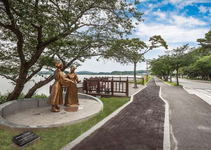
Jeong Dong Jin, Okgye
Jeongdong–Simgok Badabuchae-gil Coastal Trail
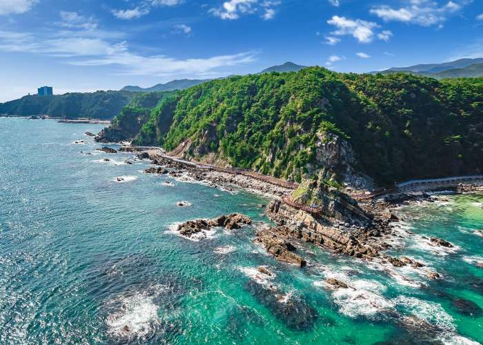
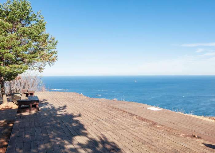
A coastal terrace formed by the waves of Jeongdongjin Beach
Introduction
Jeongdong–Simgok Badabuchae-gil is a coastal terrace formation located along Jeongdongjin Beach. It is the largest coastal terrace in Korea and is exceptionally well preserved, earning designation as a national heritage site. A 3.01 km coastal trail connecting Jeongdongjin to Simgok Port (along Heonhwa-ro) was opened in September 2016. Visitors can walk along the elevated coastal terrace and enjoy close-up views of the spectacular scenery created by waves crashing against the cliffs. The terraces appear at approximately every 10 meters up to an elevation of 160 meters, offering a chance to observe diverse coastal terrace formations.
Tour Guide
From Gangneung City, drive southeast along National Route 7 for about 8 km to reach Anin Intersection. Turn left toward Jeongdongjin and Anin-ri, then at Mojeon Intersection, turn right toward Donghae and Okgye. After driving another 8 km, you will arrive at Jeongdongjin, a famous sunrise destination. With the construction of the coastal terrace trail, visitors can now observe various formations that were previously inaccessible. Along the way, coastal guard posts and barbed-wire fences partially obscure the sea, creating a bittersweet contrast with the beautiful coastal scenery. One can look forward to the day when the fences are removed, revealing the full beauty of the blue sea and coastal terraces.
Travel Tips
The view of the coastal terrace from Jeongdongjin Sculpture Park differs greatly from the perspective seen from Okgye Beach. On the way to Okgye Beach, you can enjoy views of the Sun Cruise Hotel and yacht marina, with spaces available for relaxing with a cup of coffee or shopping. It is recommended to take your time and enjoy the coastal scenery along with various activities. The area is also popular for photography, making it an excellent destination for photography enthusiasts and groups.
-
-
Downtown
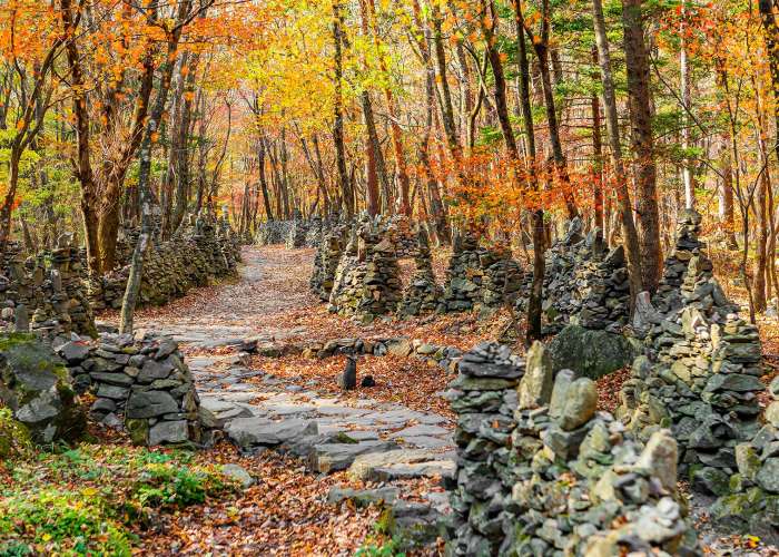
Nochusan Mojungtap Trail
A place where you can feel deep maternal devotion, featuring a spectacular view of around 3,000 stone pagodas.
Introduction
Located along the Gangneung Coffee Healing Road, the Nochusan Mojungtap Trail is a well-known hiking course where a devoted elderly mother built stone pagodas on Nochusan Mountain while wishing for the well-being of her children. There is also an auto camping site nearby; to reach the trail, follow the path at the fork opposite the camping ground. The trekking course is approximately 1.2 km long, and it takes about 1–2 hours for a round trip. A “wish mailbox” is installed in the Mojung Stone Pagoda Park, symbolizing a mother’s love for her children. Visitors are encouraged to write letters expressing their wishes for their children’s success or heartfelt messages to their loved ones.
Tour Guide
Knowing the story behind the Mojungtap makes the visit even more meaningful. The stone pagodas were built by an elderly woman named Cha Soon-ok. After her marriage, she endured a difficult life filled with family hardships. One day, she dreamed that a mountain spirit told her that building 3,000 stone pagodas in the valley would bring peace. Following this dream, she settled in the Nochusan Valley in 1986 and continued stacking stone pagodas for 26 years until her passing.
Travel Tips
If time permits, it is recommended to visit the Gangneung Coffee Museum, Anbandegi, and Nochusan Mojungtap together. Please note that there are no restrooms along the Mojungtap Trail; however, restrooms are available at the parking lot entrance. Also, there is a significant temperature difference compared to downtown Gangneung, so visiting in seasons other than winter is recommended for better scenery. Nochusan Mountain is also known as the place where the scholar Yulgok Yi I devoted himself to his studies. The name “Nochusan” originates from the idea that Yi I and the monk Seolchong achieved great scholarly accomplishments, comparable to Confucius of Lu and Mencius of Chu. The stone pagodas are built in a conical shape using natural stones. The trail itself stretches about 0.9 km, lined with approximately 3,000 stone pagodas, along with many others built by visitors. This mountain trail is located along the foothills in the area of San 716, Daegi-ri, Wangsan-myeon, Gangneung-si, Gangwon State, marking the boundary between Gangneung and Jeongseon.
-
-
Jeong Dong Jin, Okgye
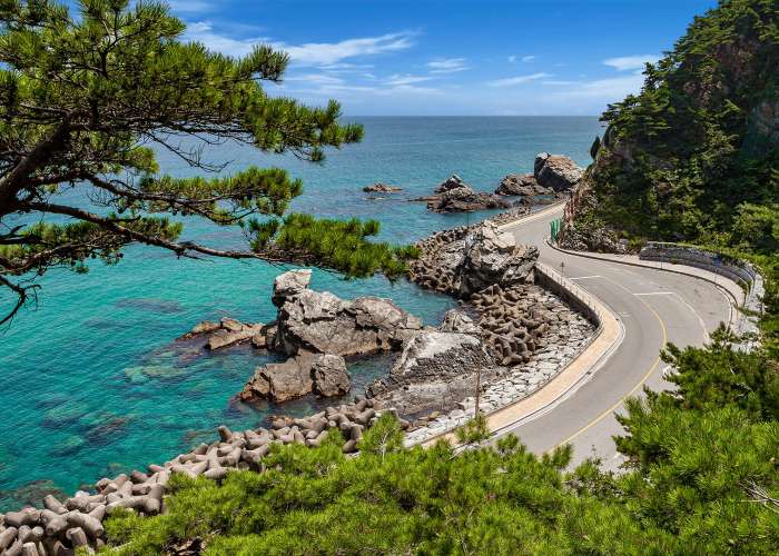
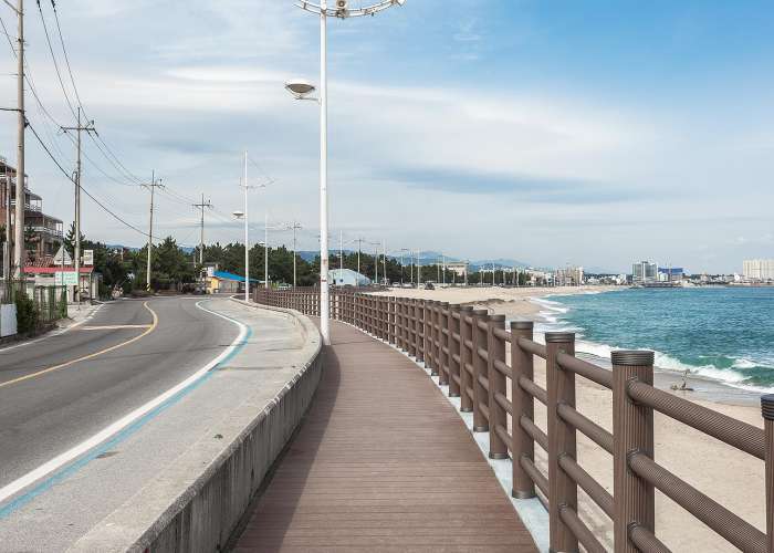
Heonhwa-ro Road
It was a stage of Hyangga Heonhwaga, a folk song of the Silla Dynasty
Introduction
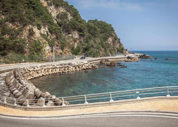
The name of Heonhwa-ro Road is orginated in Hyangga, Korean folk songs. There is a background story of the name, Heonhwa. When Sunjeonggong became a Gangneung viceroy and was on his way to go to Gangneung, his wife, Suro vicereine, asked to pick a rhododendron at a cliff of a beach. However, nobody acted among travelling companions because it was dangerous. At that time, an old guy who was leading a cattle, picked the flower and sang for her. The song is Heonhwaga. Heonhwa-ro Road is from Nakpung intersection in Okgye-myeon to Jeongdonjin Station three-way intersection in Jeongdongjin-ri, and the road has a fine view.
Tourist guide
Heonhwa-ro Road is the closest road from the ocean in Korea. It is a beach road from Simgok Port, under Jeongdongjin, to Geumjingan River. Jeongdongjin is well known for watching sunrise, so it is recommended to drive on the beach road after appreciating sunrise. Listening to the waves and admiring the blue ocean on Heonhwa-ro Road may make unforgettable memories.
Tourist Tips
There is Geumjin Beach when a driver advances towards the coast at Heonhwa-ro Road. This beach road is a 2km long roadway on marine terrace. It connects between Geumjin-ri and Simgok-ri and is surrounded by strange rock formations and cliffs. Metal fences are built around the coast for safety, and there are a small parking lot and some benches for visitors to appreciate the terrific ocean view.
-
-
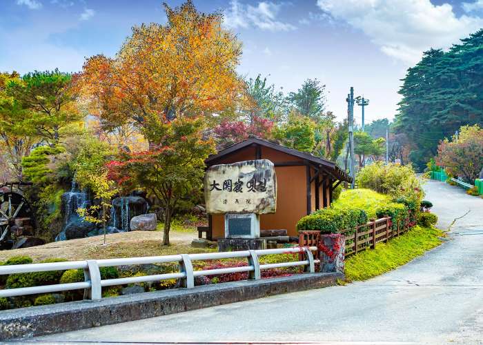
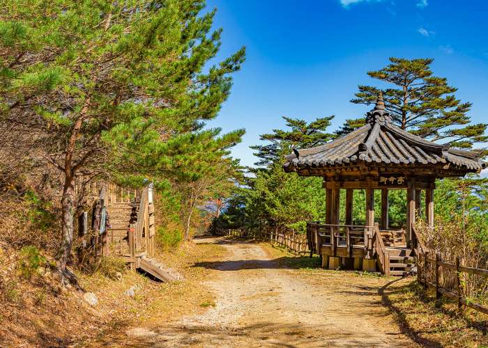
Daegwallyeong
Old Daegwallyeong Road
Old Daegwallyeong Road has the largest nature forest park in Korea.
Introduction
Old Daegwallyeong Road is a historic site in Eoheul-ri, Seongsan-myeon, Gangneung-si, Gangwon-do. This old road used to serve as the trade and transportation hubs connecting Yeongdong and Yeongseo regions during the Goryeo period and Joseon period. With the breathtaking nature’s scenery in Daegwallyeong, Old Daegwallyeong Road has preserved its original shape since being designated as Scenic site No.74 in 2010.
Tourist guide
Old Daegwallyeong Road is a forest-covered walking trail starting from the spot called “Banjeong” after Daegwallyeong pass to “Daegwallyeong Museum”. It is an around 2-hour trekking. It is also a very popular driving road visited by couples or tourists. Going out of Hoenggye Interchange in Yeongdong Highway and right before going into Daegwallyeong-myeon, Pyeongchang-gun, there is a sign board reading “Old Daegwallyong Road” standing. From here, drivers can enjoy beautiful nature’s views behind the wheel.
Tourist Tips
In the middle of the Daegwallyeong pass, there is a fork that divides into a route that goes down all the way from Banjeong, and another one that goes up to Daegwallyeong Museum or Gamagol Village. Old Daegwallyeong Road will present tourists with “healing trip” that shows nature’s views beautifully changing every season. In autumn, fantastic colorful leaves welcome tourists. Therefore, tourists and drivers can feel romantic and refreshed with a wave of red and yellow leaves along with the road.
-
-
Jeong Dong Jin, Okgye
Anbo Hiking Trail
A hiking trail that climbs along the coastline
Introduction
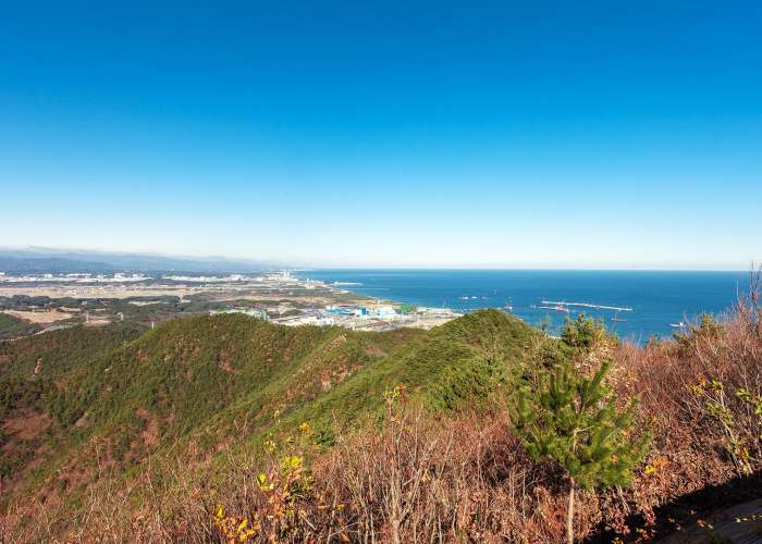
The Anbo Hiking Trail is located in the Aninjin-ri area of Gangdong-myeon, Gangneung-si, Gangwon State. Previously, Gangneung’s main hiking areas were centered around Daegwallyeong and Odaesan Sogeumgang. However, following the 1996 North Korean submarine infiltration incident, this security-themed hiking trail was newly established. After the incident brought significant attention to the area, Gangneung City organized and improved the trail in 1997, led by the Gangneung City Hall Mountaineering Club. The trail was named “Anbo” (meaning security) to emphasize the importance of strengthening national security. The nearby Anbo Park, originally developed together with an exhibition hall displaying the captured North Korean submarine, was later renamed Unification Park as tensions between North and South Korea eased.
Tourist Guide
Thanks to its stunning natural scenery, the Anbo Hiking Trail has been selected as a course for nationwide hiking competitions. Its scenic surroundings are so impressive that many workplaces and organizations host their own hiking events here. The nearby areas of Aninjin and Jeongdongjin, which can serve as starting or ending points, are well-known tourist destinations in their own right, offering a variety of attractions and dining options that draw numerous visitors. Along the coastal road, you will also find Unification Park, the North Korean Submarine Exhibition Hall, Deungmyeong Nakgasa Temple, and Haslla Art World, making it an excellent destination for families and group travelers.
Travel Tips
The Anbo Hiking Trail features two main courses.Course 1 begins at the Samgeori intersection in Aninjin 2-ri, Gangdong-myeon, and passes through Samubong Peak, Gwaebangsan Mountain, Gwaeiljae Pass, Dangjip, and Hill 183 before reaching Jeongdongjin. The total distance is 8.3 km and takes approximately 3 hours and 10 minutes.Course 2 starts from the submarine infiltration site and continues through Samubong Peak, Gwaebangsan Mountain, Gwaeiljae Pass, Dangjip, Hwabi Pass, and Cheonghaksan Mountain. The distance is 7.7 km and takes about 2 hours and 35 minutes.Both courses offer convenient access to harbors, breakwaters, sandy beaches, train stations, restaurants, and cafes at their starting or ending points, allowing visitors to relax and enjoy refreshments alongside their hike.
-
-
Jeong Dong Jin, Okgye
ヘパランギル35コース
田舎の風景と海の景色が出会う海沿いのトレッキングコース
紹介
「ヘパランギル」は「オリュクトサンライズ公園」から「統一展望台」まで続くトレッキングコースで、青い東海と山々を友として歩くことができます。全10区間、50コース、総距離770kmに及びます。
観光ガイド
玉渓市場から正東津までのコースは、穏やかな田舎の景色と海の景色を楽しみながらトレッキングができます。後半の正東津へ向かう道は、森林の小道が訪問者を迎えます。
観光のヒント
この道は「江陵バウギル第9区間」の「ヘンファロ」散策路と重なる区間があり、バウギル第9区間も合わせて体験すると、さらに楽しいトレッキングになります。最初のスポットは玉渓海水浴場で、広くて清潔な砂浜と温かい海水が特徴です。訪問者向けの施設も整っており、水遊びに最適です。2番目のスポット、金津港は江原道江陵市玉渓面金津里にある漁港で、ヒラメ、タコ、アワビなど多様な魚があり、多くの釣り人が訪れます。観光船も運行しており、多くの観光客が訪れる場所です。3番目のスポット、**深谷港(シムゴク港)**は静かで落ち着いた漁村で、谷の奥に位置することから「シムゴク」と名付けられました。最終目的地、正東津駅は江原道江陵市江東面に位置し、ドラマ「砂時計」の撮影地として有名で、観光名所として知られています。特に朝日が美しく、1月1日の初日の出を見るために多くの観光客が訪れます。訪問前に宿泊を予約することを強く推奨します。
-
-
Jeong Dong Jin, Okgye
Haeparang Trail Course 36
The most challenging section of the Haeparang Trail, known for its rugged terrain
Introduction
“Haeparang Trail Course 36” is a route that begins at “Jeongdongjin Station” and continues to “Anin Beach.” This course connects to the hiking trail of “Gwaebangsan Mountain,” requiring a moderate level of physical fitness, and offers an enjoyable trekking experience with breathtaking views of the blue East Sea from the mountain.
Tourist Guide
The course starts at “Jeongdongjin Station,” passes by “Dangjip Shrine,” and continues to “Anin Beach.” The total distance is 9.5 km, and it takes approximately 3 hours and 20 minutes to complete. The starting point of “Haeparang Trail Course 36” is “Jeongdongjin Station.” To visit the course using public transportation, take Bus No. 109 from “Gangneung Intercity Bus Terminal,” get off at the “Jeongdong Elementary School” stop, and walk approximately 400 meters.
Travel Tips
The first stop of “Haeparang Trail Course 36,” “Jeongdongjin Station,” is located in Gangdong-myeon, Gangneung-si, Gangwon State. It is widely regarded as one of the most beautiful places to watch the first sunrise of the New Year, attracting many visitors each year who come to create unforgettable memories. “Jeongdongjin Station” is also famous as a filming location for the drama “Sandglass,” and features various photo zones where visitors can capture special moments with loved ones.Continuing along the course, you will encounter “Dangjip Shrine,” which marks approximately the halfway point. After passing “Dangjip Shrine,” continue trekking toward the final destination, “Anin Beach.”At “Anin Beach,” the final stop of “Haeparang Trail Course 36,” you can admire the beautiful natural scenery where the blue sea harmonizes with the surrounding trees. “Anin Beach” is located in Anin-ri 2, Gangdong-myeon, Gangneung-si, Gangwon State. With its clear waters and shallow depth, it is a popular summer vacation destination.Near “Anin Beach” stands “Haerangdang Shrine.” According to legend, long ago, the magistrate of Gangneung enjoyed leisure activities such as swinging with a gisaeng (courtesan), but after she fell and died, storms and poor fishing began to plague the sea. The villagers built a stone altar and held rituals, but the misfortunes continued. Eventually, they crafted a wooden phallic symbol and performed a ritual, after which the storms subsided and fish became abundant again. This legend has been passed down through generations.
-
-
Downtown
Haeparang Trail Course 38
An easy course composed of low hills, farmlands, urban areas, and embankment paths.
Introduction
“Haeparang Trail Course 38” begins at the “Odokttegi Training Center” and continues to “Solbaram Bridge.” Along the trekking route, visitors can encounter “Jungang Market” and the “Dano Culture Center,” and enjoy trekking while taking in views of rural villages filled with nostalgic charm.
Tour Guide
“Haeparang Trail Course 38” starts at the “Odokttegi Training Center” and continues through “Gujeong-myeon Office,” “Mosanbong Peak,” “Jungang Market,” and ends at “Solbaram Bridge.” The total distance of the course is 18.5 km and takes approximately 7 hours to complete. Before starting the trek, visitors can access the course using public transportation. From “Gangneung Express Bus Terminal,” walk about 460 meters to “Gyotong Gas Station Stop,” then take city bus No. 101 and get off at “Saimmalgyo Stop.” From there, walk approximately 620 meters to reach the starting point of the course.
Travel Tips
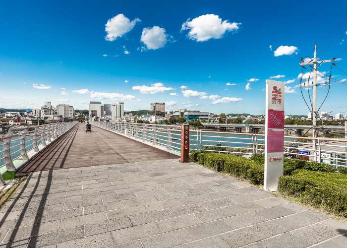
“Mosanbong Peak,” one of the highlights of “Haeparang Trail Course 38,” is a 105-meter-high mountain located in Gangnam-dong, Gangneung, and is one of the four main guardian mountains of the city. It was named “Mosanbong” because its shape resembles a mother carrying a child on her back. It is also called “Bapbong,” as it looks like an upside-down rice bowl. “Jungang Market” is a representative traditional market of Gangneung, where a variety of local specialties and foods welcome visitors, offering a chance to enjoy the authentic flavors of the region. In particular, “Samsukitang,” a signature hangover soup of Gangneung, is made with a fish called “samsuk,” known for its refreshing and clear broth. It is considered a local delicacy, and visitors—especially first-time travelers or trekkers—are highly encouraged to try it. The final destination of “Haeparang Trail Course 38,” “Solbaram Bridge,” is an arch-shaped pedestrian bridge connecting “Gangneung Port” and “Namhangjin.” It is accessible only to pedestrians and cyclists. At the center of the bridge, there is a small performance area and a rest space. At night, the bridge creates a romantic atmosphere with beautiful ocean views and lighting.
-
-
Gyeongpo Area
Haebaral-gil Course 39
A scenic course featuring coastal paths, pine forests, and lake trails, suitable for easy-level trekking.
Introduction
The “Haebaral-gil” trail stretches from “Oryukdo Sea Welcome Park” to the “Unification Observatory,” offering trekking paths where visitors can walk alongside the blue East Sea and surrounding mountains. Haebaral-gil consists of 10 sections with a total of 50 courses, spanning an impressive 770 km.
Tourist Guide
Course 39 of Haebaral-gil begins at “Solbaram Bridge” and ends at “Sacheon Jinri Beach Park.” This route is entirely composed of picturesque coastal paths, pine forests, and lake trails. Along the way, travelers can explore historic sites such as “Gyeongpodae Pavilion” and the “Heo Nanseolheon Birthplace.”
Travel Tips
Haebaral-gil Course 39 stretches 16.1 km from “Solbaram Bridge” to the “Heo Gyun & Heo Nanseolheon Memorial Hall,” “Gyeongpodae Pavilion,” and finally “Sacheon Jinri Beach.” The hike takes approximately 5 hours and 30 minutes. To reach the starting point, take bus 227 from Gangneung Intercity Bus Terminal and get off at the “Namhangjin” stop, then walk about 460 meters.“Solbaram Bridge,” connecting Gangneung Port and Namhangjin, features an arched design with colorful nighttime lighting blending with the sea for a romantic atmosphere. The central part of the bridge offers resting areas and small performance spaces for both tourists and local residents to enjoy cultural activities.The “Heo Gyun & Heo Nanseolheon Memorial Hall” is located in Chodang-dong, Gangneung-si, Gangwon-do. This park commemorates the literary spirit of the siblings Heo Gyun, author of Korea’s first Hangul novel Hong Gil-dong, and the esteemed poet Heo Nanseolheon. Visitors can explore their works and historical artifacts.“Gyeongpodae Pavilion” provides breathtaking scenery, combining beautiful pine and cherry blossom forests. Known as one of the Eight Scenic Spots of the Gwandong region, the pavilion has a traditional hipped roof with six front bays and five side bays. In spring, cherry blossoms create a spectacular view.The final destination, “Sacheon Jinri Beach,” is located in Bangdong-ri, Sacheon-myeon, Gangneung-si, Gangwon-do. This gently sloped beach with fine sand is ideal for clam digging. Surrounded by lush pine forests, it attracts many families. Visitors can also see the red lighthouse at Sacheon Jin Port, enjoy fresh sashimi, and take sightseeing cruises.
-
-
Jumunjin Area
Haeparang Trail Course 40
A trail connecting Sacheonjinri Beach Park, Yeongok Coast, and Jumunjin Beach
Introduction
The “Haeparang Trail” consists of a total of 10 sections and 50 courses, stretching approximately 770 km. The trail runs from “Oryukdo Sunrise Park” to the “Unification Observatory.” It offers visitors a trekking experience where they can walk alongside the blue sea and mountains of the East Coast.
Tourist Guide
“Haeparang Trail Course 40” begins at “Sacheonjinri Beach” and continues to “Jumunjin Market,” the largest live fish market on the East Coast. Along the way, visitors can explore “Jumunjin Lighthouse,” “Sodol Port’s Adeulbawi Rock Park,” and finally reach the beautiful sandy shores of “Jumunjin Beach.” This course is highly recommended for those who wish to enjoy the diverse coastal scenery of Gangneung.
Travel Tips
“Haeparang Trail Course 40” follows the route of “Sacheonjinri Beach,” “Yeongok Beach,” “Jumunjin,” and “Jumunjin Beach,” allowing visitors to admire stunning seaside landscapes. The total distance of this course is approximately 12.4 km, and it takes about 4 hours to complete the trek. “Sacheonjinri Beach” is located between “Gyeongpo Beach” and “Yeongok Beach,” and is adjacent to “Gyeongpo Provincial Park.” With its gentle slope and fine sand, it is a popular destination for families. After passing “Sacheonjinri Beach,” visitors will reach “Yeongok Beach,” which features a wide sandy shore and dense pine forests, making it an ideal spot not only for swimming but also for camping. Around “Yeongok Beach,” visitors can enjoy a variety of local foods, including native chicken dishes, wild vegetable set meals, and Ggukjeogutang (a traditional fish soup), representing the flavors of Gangneung throughout the seasons. Continuing past “Yeongok Beach,” the trail leads to “Jumunjin,” and a little further along, “Jumunjin Beach” comes into view. “Jumunjin Beach,” the northernmost beach in Gangneung, is characterized by its gentle slope and shallow waters. The clear seawater and well-equipped facilities for swimmers make it a popular destination visited by many tourists every year. Near “Jumunjin Beach” lies “Hyangho Lake,” where visitors can enjoy fishing, and the surrounding dense pine forests provide excellent camping opportunities.
-

-
Daegwallyeong
Baugil Trail Course 1
Seonjaryeong Windmill Trail
Introduction
Baugil Trail is a long-distance walking route of approximately 350 km that stretches from the Baekdudaegan mountain range to Gyeongpo and Jeongdongjin, offering a unique experience of walking through both mountains and the sea. The name “Baugil” originates from the Gangwon dialect word for “rock.” Course 1, the first section of the trail, follows the ridgeline of the Baekdudaegan, passing through gentle highlands lined with fences of lush sheep ranches and Korea’s largest wind power complex, whose turbines resemble white pinwheels spinning atop the mountains when viewed from afar.
Tourist Guide
Baugil Trail Course 1 is widely known among hiking enthusiasts as the Seonjaryeong Windmill Trail. Although the summit reaches 1,157 meters above sea level, the starting point is already at an elevation of about 850 meters, making the ascent relatively gentle. From the ridgeline of the Baekdudaegan, visitors can enjoy panoramic views of both the Yeongdong and Yeongseo regions. From spring to autumn, the trail transforms into a paradise of wildflowers.
Travel Tips
The Seonjaryeong Windmill Trail (Baugil Course 1) spans a total of 14.7 km. Starting from the Daegwallyeong Rest Area, the route connects to a junction leading to both Baugil Course 2 and Baugil Course 1 of Daegwallyeong. The trail passes through Hanil Ranch Road, Seonjaryeong Peak, and the East Sea Observatory before returning to the Daegwallyeong Rest Area. By taking the branch toward Course 2, visitors can reach the Guksa Seonghwangdang Shrine. Since the first section consists mainly of mountainous terrain and weather conditions can change rapidly, it is recommended to bring crampons and gaiters during winter.
-
-
Daegwallyeong
Baugil Course 3
The Royal Command Pine Tree Trail
Introduction
The pillars of Korea’s ancient temples and palaces were all made using Geumgang pine trees. Baugil Course 3 is a well-known trail that takes visitors through dense forests filled with these very Geumgang pines. This 12.5 km course begins at Bogwang-ri Automobile Village, the endpoint of Baugil Course 2, and passes Jangseung Rest Area, Eomyeongjeong Pavilion, Suljan Rock, and Myeongjugun Royal Tomb before reaching its final destination.
Tour Guide
Baugil Course 3, known as the “Royal Command Pine Tree Trail,” stretches approximately 12 km. Starting from Bogwang-ri Youth Hostel, the trail briefly ascends toward Bohyeonsa Temple, then follows a well-maintained hiking path developed by the Korea Forest Service. The route continues along forest roads and woodland trails, often referred to as “tree paths,” leading all the way to Myeongjugun Royal Tomb. The entire trail is surrounded by pine forests.Along the way, you will find Eomyeongjeong Pavilion, built at the site where large pine trees were once cut down by royal decree to be used as pillars during the restoration of Gyeongbokgung Palace. The pine forest trail is believed to be filled with the energy of tree spirits, making the walk feel effortless no matter how far you go.
Travel Tips
Due to the mountainous climate of Gangwon State, where weather conditions can be unpredictable until March, it is advisable to dress warmly and bring hot water. If steep hiking feels challenging, it is recommended to start from the endpoint at Myeongjugun Royal Tomb and walk the course in reverse.Observing the pine trees is another unique charm of Baugil Course 3. By closely examining their shapes and scars, you can feel the resilience of pine trees as they heal themselves. As you walk along the trail, fully enjoy the invigorating energy of the pine forest, which is known to contain even higher levels of phytoncides than cypress trees.