Downtown District
- Home
- Tour
- Nature Tour
- Downtown District
-
-
Downtown
Jeowangsan
The Highest Peak of the Eastern Daegwallyeong Mountain Range
Introduction
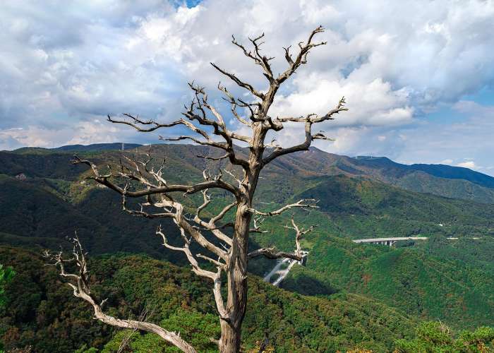
Jeowangsan is an 840-meter-high mountain located in Eoheul-ri, Seongsan-myeon, and Wangsang-ri, Wangsan-myeon, Gangneung-si, Gangwon-do. The mountain features gentle slopes, with oak forests and deciduous larch trees scattered throughout its landscape. It is one of the ridges extending east from the central line connecting Daegwallyeong and Neunggyeongbong, and it is the highest peak in the eastern Daegwallyeong mountain range.Historically, it is said that King U of the late Goryeo dynasty built a fortress on Jeowangsan and sought refuge there. Evidence of this includes stone retaining walls and roof tiles found on the mountain. Following the valley along the northern slope, visitors can encounter the remains of Jeminwon, a lodging facility on the Yeongdong Road during the Joseon era, and nearby is the Daegwallyeong Natural Recreation Forest, which provides accommodation. The boundary between Doam-myeon, Pyeongchang-gun, and Seongsan-myeon, Gangneung-si, features Seonjaryeong, and to the north, Daegwallyeong and Odaesan National Park are visible.
Tourist Guide
Jeowangsan's gentle slopes, dotted with oak and deciduous larch forests, make it ideal for leisurely hiking while enjoying fresh air and peaceful surroundings. The mountain faces Seonjaryeong at the boundary of Doam-myeon, Pyeongchang-gun, and Seongsan-myeon, Gangneung-si, and to the north, it overlooks Daegwallyeong and Odaesan National Park across the Yeongdong Expressway.A road runs through the forest from the old Daegwallyeong Service Area on the Yeongdong Expressway to Jeowangsan. Shortly after leaving the service area, hikers pass a well where traditional rain rituals were performed, then continue east along a gentle slope to reach the summit. The hike typically begins from the Daegwallyeong Service Area, following a path north to Daegwansa Temple. Ascending the steep northern ridge leads to the summit, offering breathtaking panoramic views of Gangneung and the East Sea.
Tourist Tips
The Jeowangsan hiking course spans 8.7 km, typically taking about four hours. The route goes from Daegwallyeong Service Area – Expressway Completion Monument – Forest Outpost – Observatory – Sotdae Rock – Jeowangsan Summit – Forest Outpost – Healing Forest – Jumak Street – Daegwallyeong Museum.On the northern slope, a small stream flows through Eoheul-ri, part of the upper Namdaecheon River. This stream follows the old Daegwallyeong route that historically connected Gangneung and Yeongseo regions, now used as a hiking trail. The 456 local road runs to the north. Descending along the valley, hikers encounter the stream from Eoheul-ri near the Daegwallyeong Museum, making it a pleasant detour.The area is rich with natural beauty, featuring wildflowers such as Beolgaemi-chwi and Gugyeolcho that welcome visitors. The combination of rugged rocks and pine trees resembles a delicate watercolor painting, creating a serene and picturesque landscape.
-
-
Downtown
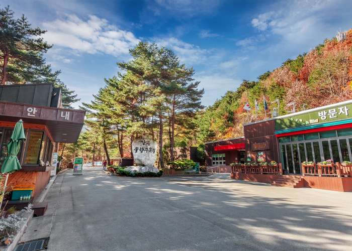
Gangneung Solhyang Arboretum
An arboretum composed of Geumgang pine trees, the representative species of the Gangneung region
Introduction
Gangneung Solhyang Arboretum spans approximately 78.5 hectares (about 240,000 pyeong) and features 23 diverse themed sections with 1,127 species and approximately 220,000 individual plants. From the entrance, visitors can enjoy the sounds of water, the fragrance of flowers, and the scent of pine trees. The arboretum includes a forest ecology observation trail formed by colonies of spicebush and snowbell trees, the “Millennial Breath Healing Path” that embodies a thousand years of waiting, the Pine Forest Plaza embraced by Geumgang pine trees, and themed gardens such as the Hosta Garden, Daylily Garden, Medicinal Plant Garden, and Dye Plant Garden showcasing a wide variety of wildflowers.
Tour Guide
Nearby attractions include Gyeongpodae, the largest scenic site in Gangneung; Seongyojang House, a traditional noble residence from the late Joseon Dynasty; Ojukheon House, the birthplace of scholar Yulgok Yi I; and Imyeonggwan Sammun Gate, where visitors can see government buildings from the Goryeo and Joseon periods. Visitors can also explore the Gangneung Coffee Museum to learn about the coffee production process and the Daegwallyeong Museum to view various stone artifacts. Other nearby attractions include the Charmsori Gramophone Museum, Jeongdongjin, Chilsadang Shrine, and Unification Park.
Travel Tips
Gangneung Solhyang Arboretum consists of 23 attractions, including the Subtropical Plant Garden, Hosta Garden, Four Seasons Garden, Hydrangea Garden, Rock Garden, Medicinal Plant Garden, Dye Plant Garden, Daylily Garden, Iris Garden, Millennial Breath Healing Path, Azalea Garden, and Sky Garden. Among these, the most notable highlights are the Forest Ecology Observation Trail, Pine Forest Plaza, Sky Garden, Rock Garden, and Tropical Greenhouse. The Forest Ecology Observation Trail features elevated wooden decks running through the forest alongside a stream, where snowbell trees form a tunnel-like canopy, offering a refreshing walk accompanied by the soothing sound of flowing water. The Sky Garden is located at the highest point of the arboretum, offering panoramic views of Gangneung city and the blue sea, while the cool breeze at the summit relieves fatigue. It also preserves the natural harmony of various plants growing among rocks. The Rock Garden was created using stones excavated during the construction of the arboretum and features coniferous trees and plants that thrive in barren conditions, creating a beautiful harmony with the rocks. The Tropical Greenhouse is the newest addition, decorated with palm trees and tropical plants, and includes a second-floor deck with tables and chairs where visitors can relax like in a café. Since 2023, nighttime landscape lighting has been installed, allowing the arboretum to operate into the evening, where visitors can enjoy beautifully illuminated trees during a night stroll. One of the biggest reasons to visit Gangneung Solhyang Arboretum is that all of these experiences are completely free. There are no parking or admission fees, making it easy to enjoy everything at no cost. The arboretum is closed every Monday (or the next weekday if Monday is a holiday). During the summer season (March–October), admission is from 09:00 to 22:00 and viewing hours are from 09:00 to 23:00. During the winter season (November–February), admission is from 09:00 to 21:00 and viewing hours are from 09:00 to 22:00. Please note that pets, bicycles, motorcycles, tents, and picnic mats are not allowed inside the arboretum.
-
-
Downtown
Chilseongsan Mountain
A 953-meter-high mountain crowned with seven rocks at its summit, resembling the Big Dipper
Introduction
Chilseongsan Mountain rises to 953 meters and spans across Eodan-ri in Gujeong-myeon, Mokgye-ri and Domari in Wangsan-myeon, Gangneung-si, Gangwon State. On the northern slope lies a wide fan-shaped plain called “Geumgwangpyeong.” The mountain was named Chilseongsan because the seven rocks at its summit resemble the Big Dipper constellation. The ridge on the left forms the boundary between Gujeong-myeon and Wangsan-myeon, while the ridge on the right separates Gujeong-myeon and Gangdong-myeon. On the eastern side of the ridge, clusters of oak trees thrive, while pine trees grow naturally in groups on the western side.
Tourist Guide
A recommended hiking course on Chilseongsan takes approximately four hours. The route starts at “Beopwangsa Temple,” passes a “transmission tower,” and continues to “Chilseongsan,” “Chilseongdae,” and “Danggyeonggol,” before returning to “Beopwangsa Temple.” Beopwangsa Temple is easily accessible by exiting at “Namgangneung IC” from the Yeongdong Expressway.
Travel Tips
The hiking course begins at Beopwangsa Temple. About 30 meters along the valley from the temple, you will find a ribbon tied to a tree on the opposite side to the left. Crossing this valley leads to the ridge trail that serves as the entrance to Chilseongsan. Upon reaching “Chilseongdae” after climbing Chilseongsan, visitors are greeted by magnificent rock formations encircling the surrounding mountains, along with beautiful old pine trees growing among unusual rock formations. It takes approximately 2 hours and 20 minutes from the starting point to reach Chilseongdae. Around the summit, striking rock formations blend harmoniously with the natural scenery. To the east of the summit, visitors can enjoy panoramic views of the Gangneung coast, “Geumgwangpyeong,” and downtown Gangneung, along with Beopwangsa Temple. For the descent, follow the ridge trail from the summit back to Beopwangsa Temple. Alternatively, descending along the ridge near a small helipad leads to Tapdong Village in Domari, Wangsan-myeon, along National Route 35 toward Imgye, Jeongseon. The descent also features scenic combinations of unique rock formations and old pine trees, and the extended ridge connecting to Wangsan offers beautiful natural views. About 50 minutes down from the Chilseongsan peak, you will encounter a bamboo grove, and a little further down lies “Gwaneumsa Temple.” It takes approximately 2 hours and 30 minutes from Chilseongdae to Gwaneumsa Temple. As this trail is not frequently used, extra caution is required.
-
-
Downtown
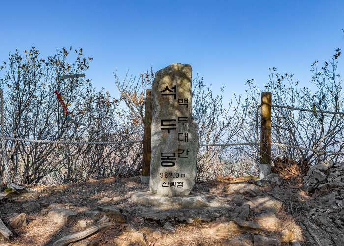
Seokdubong Peak
A towering summit rising along the majestic Baekdudaegan Mountain Range
Introduction
Seokdubong is a 982-meter-high peak located in the inner valley of Garsaejaengi in Daegi 2-ri, Wangsan-myeon. It faces Hwaranbong, which is approximately 1,000 meters in elevation, at a suitable distance and height along the Baekdudaegan hiking trail. Although the trail is relatively gentle, it takes about 7 hours and 30 minutes to complete, so visitors are advised to prepare sufficient snacks and meals for the hike.
Tourist Guide
Seokdubong was once considered one of the most remote mountains in Gangwon State and was rarely visited in the past. Today, however, it is well known among hiking enthusiasts as a mountain offering excellent panoramic views from its summit. The western peak, slightly lower than the eastern peak of Seokdubong, features uniquely patterned rocks facing each other. Along the ridge line, the eastern and northern slopes are steep, while the southern and western areas form relatively flat basins that include Garsaejaengi and Daeyongsudong.
Travel Tips
To hike Seokdubong, it is recommended to first drive up to the summit of Sapdangnyeong Pass. From Gangneung, head toward Daegwallyeong, then take National Route 35 to the left toward Imgye. Along the way, you will pass Obong Reservoir, which serves as a water source for Gangneung residents. Continuing up the steep mountain road, you will reach Sapdangnyeong, named for its trident-like shape. At the top of the pass, there is a Seonghwangdang shrine on the right; to reach Seokdubong, take the path next to the shrine. This area is mostly covered with oak trees.As you follow the Seokdubong trail, you will encounter dense forests formed by broadleaf trees and dwarf bamboo. After about 40 minutes of hiking, you will meet a forest road halfway up the mountain. Upon reaching the long-awaited rocky mountain, Seokdubong, you will be greeted by an open sky that seems to touch the peaks. The summit is covered with rocks, and azaleas growing between them welcome visitors. Next to the summit is a large rock where you can climb up and enjoy the view of Yongsugol Valley while breathing in the fresh mountain air. On the descent from Seokdubong, you will come across a wide flat area inhabited by old broadleaf trees, as well as clusters of ancient pine trees. From this point, the trail continues downhill, making for an easier return.
-
-
Downtown
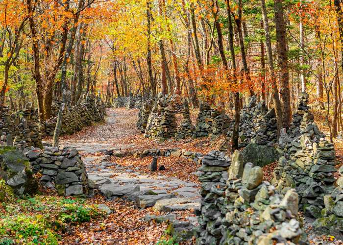
Nochusan Mojungtap Trail
A place where you can feel deep maternal devotion, featuring a spectacular view of around 3,000 stone pagodas.
Introduction
Located along the Gangneung Coffee Healing Road, the Nochusan Mojungtap Trail is a well-known hiking course where a devoted elderly mother built stone pagodas on Nochusan Mountain while wishing for the well-being of her children. There is also an auto camping site nearby; to reach the trail, follow the path at the fork opposite the camping ground. The trekking course is approximately 1.2 km long, and it takes about 1–2 hours for a round trip. A “wish mailbox” is installed in the Mojung Stone Pagoda Park, symbolizing a mother’s love for her children. Visitors are encouraged to write letters expressing their wishes for their children’s success or heartfelt messages to their loved ones.
Tour Guide
Knowing the story behind the Mojungtap makes the visit even more meaningful. The stone pagodas were built by an elderly woman named Cha Soon-ok. After her marriage, she endured a difficult life filled with family hardships. One day, she dreamed that a mountain spirit told her that building 3,000 stone pagodas in the valley would bring peace. Following this dream, she settled in the Nochusan Valley in 1986 and continued stacking stone pagodas for 26 years until her passing.
Travel Tips
If time permits, it is recommended to visit the Gangneung Coffee Museum, Anbandegi, and Nochusan Mojungtap together. Please note that there are no restrooms along the Mojungtap Trail; however, restrooms are available at the parking lot entrance. Also, there is a significant temperature difference compared to downtown Gangneung, so visiting in seasons other than winter is recommended for better scenery. Nochusan Mountain is also known as the place where the scholar Yulgok Yi I devoted himself to his studies. The name “Nochusan” originates from the idea that Yi I and the monk Seolchong achieved great scholarly accomplishments, comparable to Confucius of Lu and Mencius of Chu. The stone pagodas are built in a conical shape using natural stones. The trail itself stretches about 0.9 km, lined with approximately 3,000 stone pagodas, along with many others built by visitors. This mountain trail is located along the foothills in the area of San 716, Daegi-ri, Wangsan-myeon, Gangneung-si, Gangwon State, marking the boundary between Gangneung and Jeongseon.